About
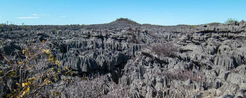
Ankarana Special Reserve in northern Madagascar was created in 1956. It is a small, partially vegetated plateau composed of 150-million-year-old Middle Jurassic limestone. With an average annual rainfall of about 2,000 millimetres (79 in), the underlying rocks are susceptible to erosion, thereby producing caves and underground rivers—a karst topography. The rugged relief and the dense vegetation have helped protect the region from human intrusion. The plateau slopes gently to the east, but on the west it ends abruptly in the "Wall of Ankarana", a sheer cliff that extends 25 kilometres (16 mi) north to south, and rises as high as 280 metres (920 ft). To the south, the limestone mass breaks up into separate spires known as tower karst. In the center of the plateau, seismic activity and eons of rainfall have dissolved the limestone away in deep gorges, and sometimes redeposited it in ribbons of flowstone. In places where the calcific upper layers have been completely eroded, the harder base rock has been etched into channels and ridges known as tsingy.The largest sinkhole in the Ankarana karst region, Mangily sinkhole, measures up to 700 metres (2,300 ft) across and 140 metres (460 ft) deep with a volume of 25 million cubic metres (33,000,000 cu yd). The area is sacred to the Antankarana people, who have historically taken refuge from encroaching enemy armies in its caves and other natural rock shelters. == Exploration == Beginning in the 1960s, expatriate Frenchman Jean Duflos (who married locally and changed his name to Jean Radofilao) did a huge amount of exploration of the cave systems and subterranean rivers of the Massif, much of it on his own or with visiting speleologists. SOURCESWikipedia
Safari Tours
15-Day Madagascar Ultimate Nature & Wildlife Adventure
10-Day Wildlife and Island Bliss in Northern Madagascar
14-Day North Nosy Be - Ankarana - Amber Mountain - Diego
9-Day Islands, Beaches and Wilderness
8-Day Amber & Ankarana Exploration
6-Day North Tour from Antsiranana to Nosy Be
12-Day The Beauty of the North of Madagascar
11-Day Northern Madagascar, an Uncharted Adventure
12-Day The Nature Wonder of the North
7-Day Big North - Spectacular Tour of Madagascar